
-
About
Introduce to the District
History-Tradition
Geographic & Economic
Miscellaneous
-
Administration
Deputy Commissioner
Additional Deputy Commissioners
Officers & Staffs
Section Related
Resolutions of Meeting
Important Information
Innovation Activities
- District Magistracy
-
Govt. Offices
Security & Discipline Affairs
Education and Culture
Agriculture & Food
Health Related
Engineering
Communication & Engineering
Human Resources
-
Dept. of Social Service
-
Dept. of Youth Development
-
Dept. of Women Affairs
-
BRDB
-
Cooperation Office
-
Islamic Foundation
-
Jatyo Mohila Sangstha
-
Government Children's Family (Boy), Lakshmipur
-
Protibondhi Seba O Sahajyo Kendro, Lakshmipur
-
UCDO Lakshmipur
-
Bangladesh Investment Development Authority (BIDA)
-
ebek.lakshmipur.gov.bd
-
Lakshmipur TTC
Other offices
-
Office of the Tax Commissioner
-
Office of the District Register
-
Customs & Duty
-
District Relief and Rehabilitation Office
-
District Savings Office
-
District Accounts Office
-
District Election Office
-
Passport Office
-
Local Statistics Office
-
Bakhrabad Gas Distribution Co. Ltd.: Laxmipur
-
Forest Dept.
-
জেলা সরকারী গণগ্রন্থাগার, লক্ষ্মীপুর
-
e-Mutation
-
Call to Doctor
-
BISIC
-
Dept. of Social Service
-
Local Govt.
District Council (Lakshmipur)
Municipality
Upazila Parishad
Union Council
-
Other Organizations
Educational Institutions
- সেবা সমূহ
-
E-Services
E-Services
National E-Service
- Gallery
-
About
Introduce to the District
History-Tradition
Geographic & Economic
Miscellaneous
-
Administration
Deputy Commissioner
Additional Deputy Commissioners
Officers & Staffs
Section Related
Resolutions of Meeting
Important Information
Innovation Activities
-
District Magistracy
Executive Court
Mobile Court
-
Govt. Offices
Security & Discipline Affairs
Education and Culture
Agriculture & Food
Health Related
Engineering
Communication & Engineering
Human Resources
- Dept. of Social Service
- Dept. of Youth Development
- Dept. of Women Affairs
- BRDB
- Cooperation Office
- Islamic Foundation
- Jatyo Mohila Sangstha
- Government Children's Family (Boy), Lakshmipur
- Protibondhi Seba O Sahajyo Kendro, Lakshmipur
- UCDO Lakshmipur
- Bangladesh Investment Development Authority (BIDA)
- ebek.lakshmipur.gov.bd
- Lakshmipur TTC
Other offices
- Office of the Tax Commissioner
- Office of the District Register
- Customs & Duty
- District Relief and Rehabilitation Office
- District Savings Office
- District Accounts Office
- District Election Office
- Passport Office
- Local Statistics Office
- Bakhrabad Gas Distribution Co. Ltd.: Laxmipur
- Forest Dept.
- জেলা সরকারী গণগ্রন্থাগার, লক্ষ্মীপুর
- e-Mutation
- Call to Doctor
- BISIC
-
Local Govt.
District Council (Lakshmipur)
Municipality
Upazila Parishad
Union Council
-
Other Organizations
Educational Institutions
-
সেবা সমূহ
Vision and Mission
Revenue Section
General Section
সংস্থাপন শাখা
Nezarot Section
Judicial Munshikhana Section
-
E-Services
E-Services
National E-Service
- Gallery
Original picture of the land that is presently located in Laxmipur district was not the same. Most of the oceanic waves of the Bay of Bengal were drunk. Famous Chinese traveler Hiuen Tsang describes 'Kamalank' as the sea coast in his travelogue 'Siuati'. 'Kamalanka' is now the ancient name of Comilla and Tripura district of Comilla. Poet Kalidas called 'Suhmi Desh' 'Taliban Shyamkantha' in his 'Raghu Dynasty' poetry. The southern part of Comilla district and the northern part of Noakhali has been defined as 'Suhmi Desh'. Since ancient times, there are many tails in these areas. It is said that in the beginning of the first decade of the thirteenth century, Chandra Nath, the founder of the state of Bhulua, moved to Murshidabad and Chittagong (Chatgaon) boat on his way to the pilgrimage. It was definitely new jogas. Perhaps at that time, the smallest part of Raipur and Ramganj, which belonged to Tripura district, was an ancient land. At present, most of the land of Lakshmipur district is rising from river or sea pond gradually becoming a char or island. For this reason, the name of different areas of the district is associated with Chor, Dhi, Di, Dia. Areas that have been associated with Puranas or Ganjs are not the oldest. New settlers have added these. Just two hundred years ago, the Scottish traveler Dr witnessing the landscape of the region. Francis Buchanan wrote (2 March 1798) "Perhaps there were peas at times or maybe even the region was formed with the sand of the river. All the soils are soft, loosened; It is mixed with the Avaral sand particle and the soil layer is not formed. Moreover, the clay is not here. (5 March 1798) The cultivation that has been cultivated in the area between leaf hats (Charpata, Raipur) and Laxmipur, is not so rich in land between Laxmipur and Noakhali. The village is inhabited by many people and many areas are still lying in a natural state, in the vicinity of the trees. Compared to leaf hats, the ground is low and every pond is full of trees in the Sundarbans. "Describing the history of Noakhali historian Parry Mohan Sen (1940)," Laxmipur region was once part of the Bay of Bengal. Once upon a time that a lot of Urmimala emerged and created fear of man, the place was once occupied by the evacuation. At that place, many people are happily living happily. " According to the description of Kader (1991) it is seen that the vast land under the Feni river east of the Meghna river in the west, Tripura (Comilla) district, this vast land is under the sea. 'When the new land wakes up, people of different parts of the country are celebrating the cultivation of the country and the foreigners of Arab countries Builds settlements for promotion of trade and religion. Then the people of Lakshmipur survived by fighting against the meghna river and in adverse nature. One-time prosperous city Islabad was destroyed in the river Meghna, which has become more extinct in the river during the period, which is mentioned in the descriptions of the sea coastal and many famous and famous populations of the river Meghna and the port city of Ibn Battuta.
Today's Laksmipur District, which has been known to find any past existence in history, is known for its lack of history, the contemporary historians have commented on different occasions. This area is specially marked from the time of the formation of the 'Bholua' state of the world. At that time, the border of the Bhulua ranged from west to the Meghna river. As such Laxmipur district was under the control of Bhulua. Fakhruddin Mubarak Shah Buluya won the mid-seventies. Here he established the eastern capital and appointed a governor. A strong naval base was set up to protect the Meghna coastal borders. Then the affectionate Meghna river flows east-west over Farashganj and Bhabaniganj. Note that in Bhulua pargana, there was a village named Bhulua, which was about 15 miles southwest of Maizadi (Noakhali) city and 3 miles before Bhabaniganj (Laxmipur). There was a border between Bhuula village in present town Kasba and Teewarganj villages.
In the seventeenth century, the Mughals occupied the bhulua. In the navigable Mughal era, this city was known as 'Kasba Kasba', which was the main naval base of the Mughals in the east. In the middle of the seventeenth century, during the time of Emperor Shahjahan, Subedar Shaista Khan Sandwip of Bengal and the Portuguese Pirates of Chittagong and Arakan were dispatched from Lalbagh Durg in Dhaka during the campaign against the Arakan; In Chandpur, on the way to the Dakatia and Meghna rivers, they come to town and join the naval force. Thus, the southern and western boundaries of Lakshmipur district can be identified. The north and eastern boundaries were in force for the present time.
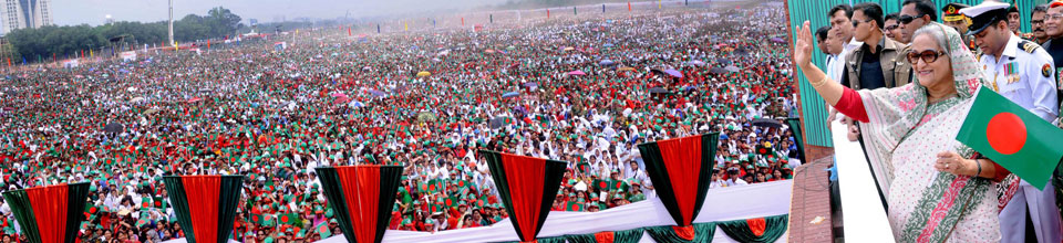
Lakshmipur was under the rule of Bhulua in the thirteenth century. During the Mughal and East India Company's rule, there was a military establishment at Lakshmipur. From the sixteenth to nineteenth century, there was a great amount of salt in the area and there was export outside. The reason for the salt is the salt revolution. Lakshmipur people participate in Swadeshi Movement spontaneously. During this time Mahatma Gandhi visited this region. He often used to live in Kafilatli Akhra and Ramgonj Serampore Rajbari. Rebel poet Kazi Nazrul Islam visited Laksmipur in June 1926. In 1971, during the Great War of 1971, there were seven wars between the Pak army and freedom fighters. Here are three memorial pillars, two mass graves and one genocide center.
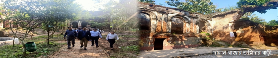
During the East India Company, Lakshmipur was rich in salt and textile industries. Salt houses and kuthi houses controlled the art. Sahapur kuthi house, zakisin kuthi house and raipur festival


Planning and Implementation: Cabinet Division, A2I, BCC, DoICT and BASIS
Technical Assistance:
![]()
Developed By:
